Historical Sources
L&DFLHS 'Digital Archive of Leconfield Sources' now available at Issue 3
In December 2025 the Society made available the third issue of its Digital Archive of Leconfield Sources, DALS.
The Leconfield archive is a large collection of records held privately at Cockermouth Castle, covering the extensive Honour of Cockermouth and the Cumberland estates of the Percy family, lords of Northumberland, and their successors since circa 1400. The castle is not open to the public but since October 2024 the Society has been given access by Lord Egremont, the owner, for three study weeks. During that period a substantial archive has been created and joined with other material to make this archive, which now includes over 42,000 images.
See an introduction here, and the content of Issue 3 here. The full catalogue of the DLEC archive can be found in Cumbria Archive Service's CASCAT facility online. The archive is available to Society Members to borrow on a memory stick/flash drive, under an agreement which is intended, essentially, to prevent the publication of the images themselves unless complying with the rights of those holding the original material. It is also available to others in the UK for bona-fide projects involving the local history of our area, at the discretion of the Editor. There is no charge for the images but there may be a charge to recover the cost of the flash drive and its delivery.
A copy has been deposited with the Cumbria Archive Service for use at the Whitehaven office initially, but with more extensive access becoming available.
For further information please contact the Editor, Derek Denman.

L&DFLHS 'Digital Archive of Historical Sources' now at issue 3
In February 2023 the Society made available the first issue of its Digital Archive of Historical Sources, DAHS. In February 2025 issue three was released, reconfigured to match with the new Digital Archive of Leconfield Sources, DALS, (see above).
The DAHS is a large collection of copies, mainly photographs, of primary historical sources which have been collected during the thirty years of the Society. See an introduction here, and the content of Issue 3 here. It is available to Society Members to borrow on a memory stick/flash drive, under an agreement which is intended, essentially, to prevent the publication of the images themselves unless complying with the rights of those holding the original material. It is also available to others in the UK for bona-fide projects involving the local history of our area, at the discretion of the Editor. There is no charge for the images but there may be a charge to recover the cost of the flash drive and its delivery.
The DAHS contains basic notes on the content and use of the records, and a geographical finder is included to simplify the task of identifying the records relevant to a particular project. The content will grow with subsequent issues, but the content is by no means comprehensive. It will assist researchers in starting a project and making progress from home, but will often need to be followed up with searches of the local record offices and possible The National Archives to provide more specialised sources.
For further information please contact the Editor, Derek Denman.
L&DFLHS 'New Domesday' records
In 2020 the Society created a digital resource containing the records for our area of the land valuation survey undertaken during 1909-15. This resource of images held at Cumbria Archive Centre, Carlisle, and The National Archives, is not an online resource, but images for particular properties can be requested and sent by email. These records are also contained in the Digital Archive of Historical Sources, above.
The content and how to access is give on this page. The complete records are included the Digital Archive of Historical Sources, above.
L&DFLHS on-line sources
Memorial Inscriptions.
The Society is transcribing the Memorial Inscriptions for the burial grounds within its area. Below you may download the Lorton and Loweswater MIs for personal research only:
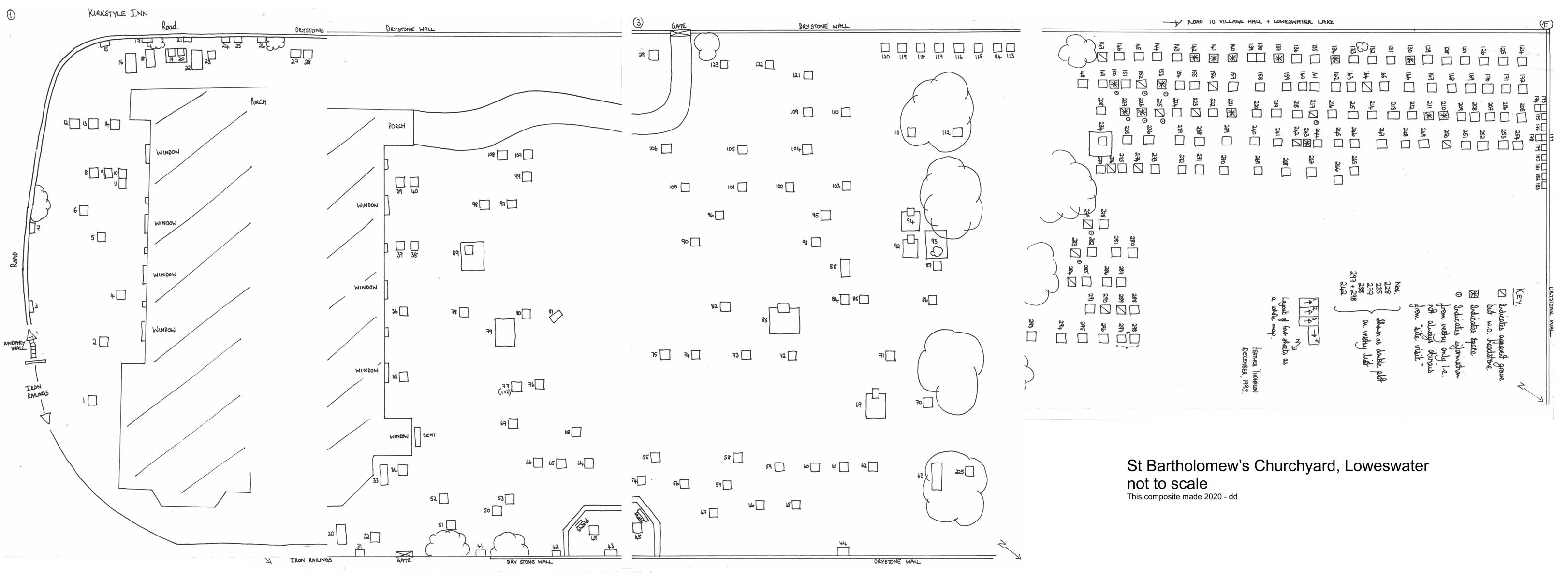
![]() Loweswater
Memoral Inscriptions. (PDF)
Loweswater
Memoral Inscriptions. (PDF)
(To view : Left click on the PDF icon - To
Download : Right Click and Select "Save As", "Save Linked File
As", ...)
The plan of the Churchyard can be viewed here.
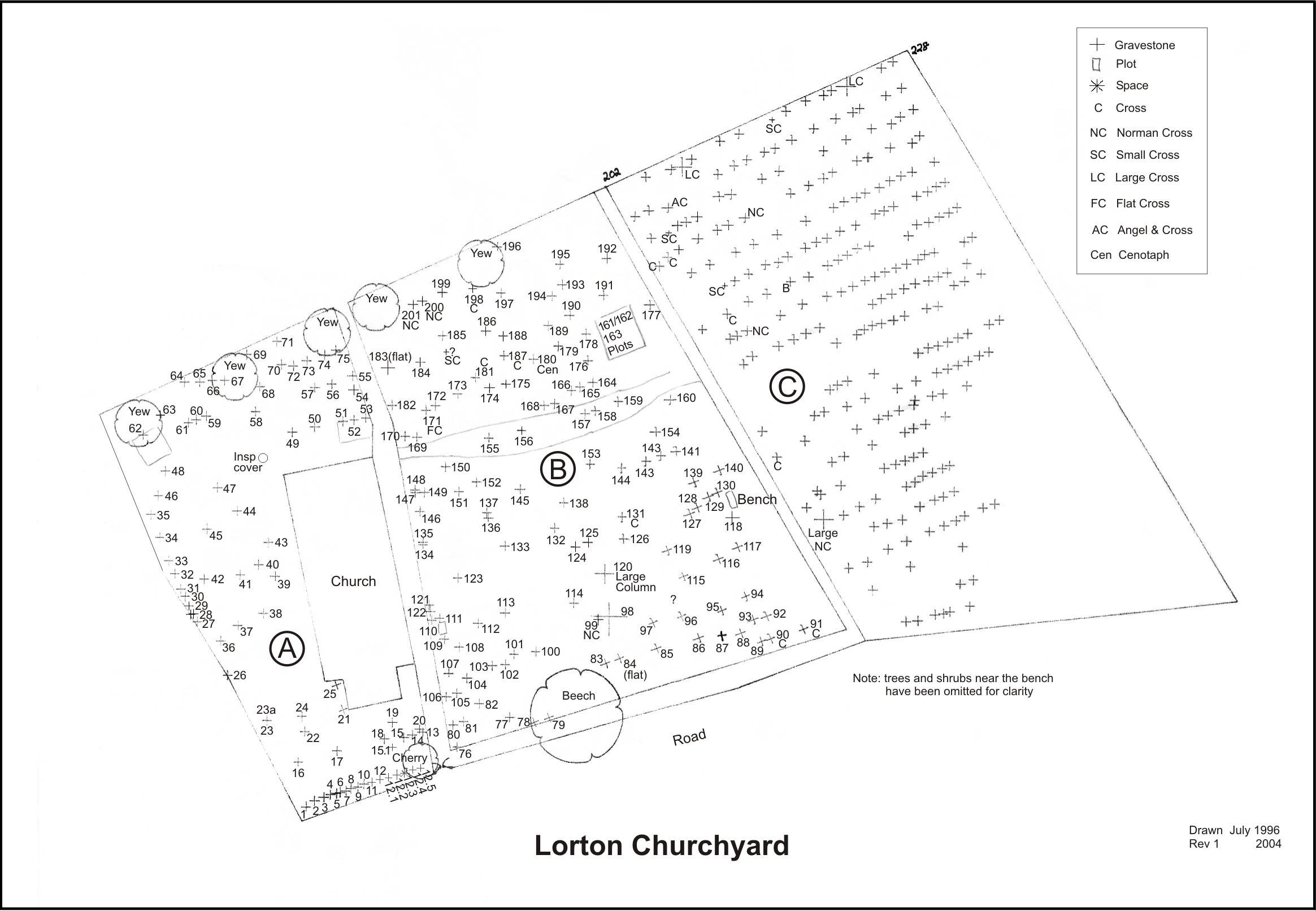
![]() Lorton
Memorial Inscriptions. (PDF)
Lorton
Memorial Inscriptions. (PDF)
(To view : Left click on the PDF icon - To
Download : Right Click and Select "Save As", "Save Linked File
As", ...)
The plan of the Churchyard can be viewed here.
Our Victoria County History (vch) sources
While contributing our Jubilee Digests for this project, the Society collected a good deal of information arranged by VCH place, generally civil parishes, and VCH topic. This includes detailed boundaries, and can be viewed here.
Links to Sources
We are now using the links to sources and recources for local history, provided by Cumbria Local History Federation website. Follow this link:
![]()

Crummock and Buttermere by William Green